World Map Configuration
LibreNMS comes with a configurable Geo Map based on World Map Widget to visualize where your equipment is located geographically.
World Map Widget
World Map Widget, requires you to have properly formatted addresses in sysLocation or sysLocation override. As part of the standard poller these addresses will be Geocoded by Google and stored in the database.
Location resolution happens as follows
- If
device['location']contains[lat, lng](note the square brackets), that is used - If there is a location override for the device in the WebUI and it contains
[lat, lng](note the square brackets), that is used. - Attempt to resolve lat, lng using
lnms config:set geoloc.engine - Properly formatted addresses in sysLocation or sysLocation override, under device settings.
Example:
[40.424521, -86.912755]
or
1100 Congress Ave, Austin, TX 78701 (3rd floor cabinet)
We have two current mapping engines available:
- Leaflet (default)
- Jquery-Mapael
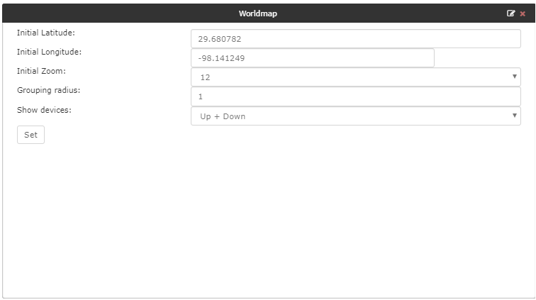
World Map Widget Settings
- Initial Latitude / Longitude: The map will be centered on those coordinates.
- Initial Zoom: Initial zoom of the map. More information about zoom levels.
- Grouping radius: Markers are grouped by area. This value define the maximum size of grouping areas.
- Show devices: Show devices based on status.
Example Settings:
Device Overview World Map Settings
If a device has a location with a valid latitude and longitude, the device overview page will have a panel showing the device on a world map. The following settings affect this map:
# Does the world map start opened, or does the user need to clivk to view
lnms config:set device_location_map_open false
# Do we show all other devices on the map as well
lnms config:set device_location_map_show_devices false
# Do we show a network map based on device dependencies
lnms config:set device_location_map_show_device_dependencies false
Offline OpenStreet Map
If you can't access OpenStreet map directly you can run a local tile server. To specify a different url you can set:
lnms config:set leaflet.tile_url 'localhost.com'
Additional Leaflet config
lnms config:set map.engine leaflet
lnms config:set leaflet.default_lat "51.981074"
lnms config:set leaflet.default_lng "5.350342"
lnms config:set leaflet.default_zoom 8
# Device grouping radius in KM default 80KM
lnms config:set leaflet.group_radius 1
# Enable network map on world map
lnms config:set network_map_show_on_worldmap true
# Use CDP/LLDP for network map, or device dependencies
lnms config:set network_map_worldmap_link_type xdp/depends
# Do not show devices that have notifications disabled
lnms config:set network_map_worldmap_show_disabled_alerts false
Note
If entering negative coordinates, use this format:
lnms config:set leaflet.default_lng -- -5.350342
Geocode engine config
external/location
lnms config:set geoloc.engine google
lnms config:set geoloc.api_key 'abcdefghijklmnopqrstuvwxyz'
Google:
Pros: fast, accurate
Cons: requires a credit card even for a free account
MapQuest:
Pros: free, no credit card required
Cons: inaccurate: most addresses are returned as locations at the center of the US
Bing:
Pros: free, no credit card required, accurate
Cons: Microsoft (debatable)
Jquery-Mapael config
Further custom options are available to load different maps of the world, set default coordinates of where the map will zoom and the zoom level by default. An example of this is:
lnms config:set map.engine jquery-mapael
lnms config:set mapael.default_map 'mapael-maps/united_kingdom/united_kingdom.js'
lnms config:set mapael.map_width 400
lnms config:set mapael.default_lat '50.898482'
lnms config:set mapael.default_lng '-3.401402'
lnms config:set mapael.default_zoom 20
A list of maps can be found in html/js/maps/ or html/js/mapael-maps/.